The storm and resulting floods that occurred in September 2013 over the northern Colorado Front Range required many key ingredients that rarely occur over the region all at the same time.
- A Deep Moisture Source
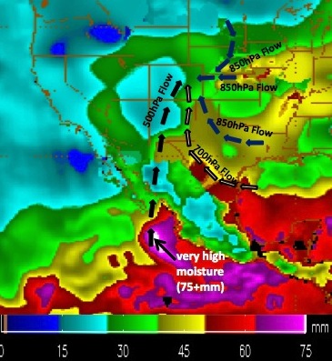
During the entire duration of this storm event, deep moisture continually entrained into the region from the Pacific, off the coast of Mexico (see figure below). Total precipitable water over the area was around 1.2 inches - a value that is more common during the hottest time of year and with the monsoon (late July and early August).
- Slow Moving Low Pressure System
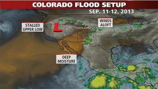
Large low pressure systems are generally more common in the winter months, but in the winter, they typically move too fast. A stationary low pressure center settled west of Colorado (figure below) and was blocked from moving out by a high pressure center to the east. This setup allowed the upper level flows to continuously pump moisture into the region, from near the surface to high in the atmosphere.
- Instability and Lift
The presence of a stalled cold front provided the initial instability. The placement of the front and the low pressure center generated the upslope flow along the foothills, which provided more lift with the instability. The instability and moisture combined to produce heavy rainfall from the higher elevations east of the Continental Divide, across the foothills and into the Front Range. And since the storm was stationary, that heavy rainfall continued over a longer period of time than what is normal for the area. - Saturated Soils
One of the major factors in the flooding was saturated soils. Although the plains had been drier for some period of time, the higher elevations east of the Continental Divide had been receiving fairly consistent precipitation for most of August and the first week of September. These persistent rains help saturate the soils, so if a major event occurred (like it did the second week of September), most of the rain would run off into the rivers, instead of infiltrating the soils. Add to this that some of the heavy rains also occurred over burn scar areas, where it's more difficult for rain to infiltrate the soils, and the runoff was exacerbated.
On September 27, several researchers in the Department of Atmospheric Science at Colorado State University presented some initial findings about the storm event. See their presentations here:
Initial Analysis of the Synoptic and
Mescoscale Features, and Initial Forecasts
By Russ Schumacher
Radar Imagery of the Rain Event
By Steven Rutledge
Satellite Imagery of the Rain Event
By Dan Lindsey