

|
|
EFFECTS ON DROUGHT
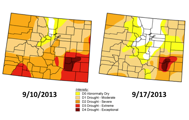 Prior to the start of this event, the majority of Colorado was experiencing severe or worse drought
conditions (top left). Most of the area had been in drought for more than one year. Only recent
improvements had been made east of the Continental Divide in Boulder and Larimer counties (where the white
is showing on the map), based on beneficial summer precipitation in the higher elevations. East of the foothills though, conditions
were still drier, and the most recent weeks leading up to the event were very hot and dry for the Front
Range.
Prior to the start of this event, the majority of Colorado was experiencing severe or worse drought
conditions (top left). Most of the area had been in drought for more than one year. Only recent
improvements had been made east of the Continental Divide in Boulder and Larimer counties (where the white
is showing on the map), based on beneficial summer precipitation in the higher elevations. East of the foothills though, conditions
were still drier, and the most recent weeks leading up to the event were very hot and dry for the Front
Range.
As a result of the widespread, heavy event that occurred over the second week of September, large scale
improvements were made to the U.S. Drought Monitor map (top right). Fractional coverage with no drought
(white area) increased from 2% to 16%, and severe drought and worse fractional coverage decreased from 58%
to 17%. The last time the entire northern Colorado Front Range was not experiencing drought (D1 - D4) was
in April 2012.
The Colorado Climate Center provides weekly drought and climate summaries.
 September 17, 2013
Summary September 17, 2013
Summary
September 10, 2013
Summary
Most
Recent Summary
U.S. Drought
Monitor
|
|